Search
Close this search box.
Search
Close this search box.

Building a catio

Want to build a catio? Register your interest for our catio rebate program coming in 2024.

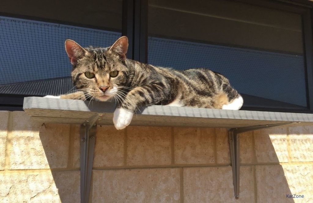
Domestic cats can thrive in a contained environment.

Contained cats can live up to four times longer than roaming cats, and can live happy, healthy and fulfilled lives if all of their needs are met in the contained environment.

What is a catio?

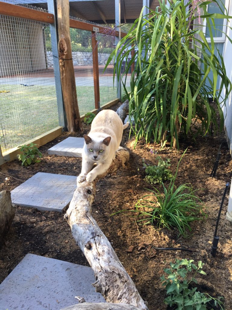
A catio is a secure outdoor cat enclosure, or “cat patio” for your cat.

Catios are a great way of allowing your cat to enjoy the sights, sounds and smells of the outdoors while keeping them safe and protecting our native wildlife. Cats are healthy and purrfectly happy in a catio, provided it is designed to deliver mental and physical enrichment.

Top 10 benefits of a catio

Catios will support you and your cat by:

  1. Protecting your cat from vehicles, poisons, diseases accidents, or getting lost.
  2. Reducing vet bills from cat fights, ingesting toxins or injuries.
  3. Protecting birds and wildlife: billions of birds are killed each year by roaming cats.
  4. Reducing roaming populations and the issues they cause, including more roaming cats.
  5. Providing a healthy outdoor lifestyle with exercise, fresh air, bird watching, sunbathing, jumping, climbing and running.
  6. Reducing multi-cat issues with increased territory and multiple options for some ‘alone’ time.
  7. Enriching cat and human companionship by providing shared healthy outdoor spaces to relax in.
  8. Reducing indoor odours by giving outdoor toilet options.
  9. Improving neighbour relations – made easier  when your cat stays on your side of the fence!
  10. Providing you with peace of mind, knowing your cat is safe in a protected and secure environment.

Types of catios

There are always opportunities to expand your cat’s territory in a responsible way. Even if you are not able to build a catio structure there is plenty you can do indoors to enrich your feline’s environment.
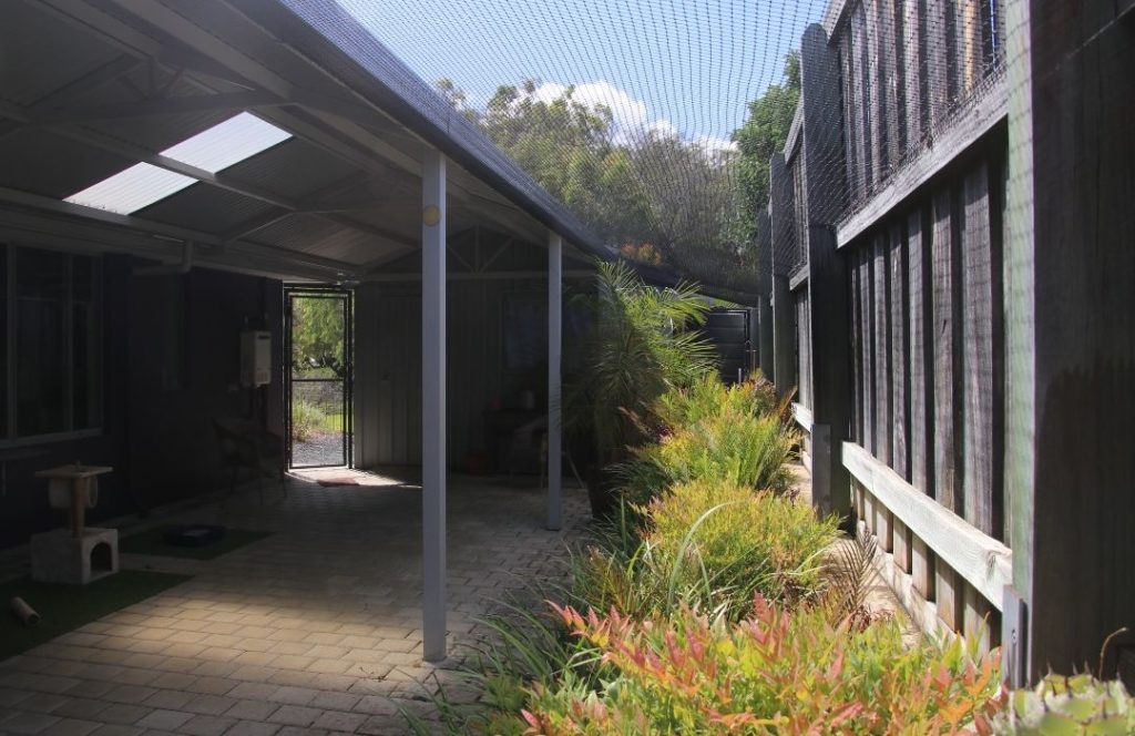
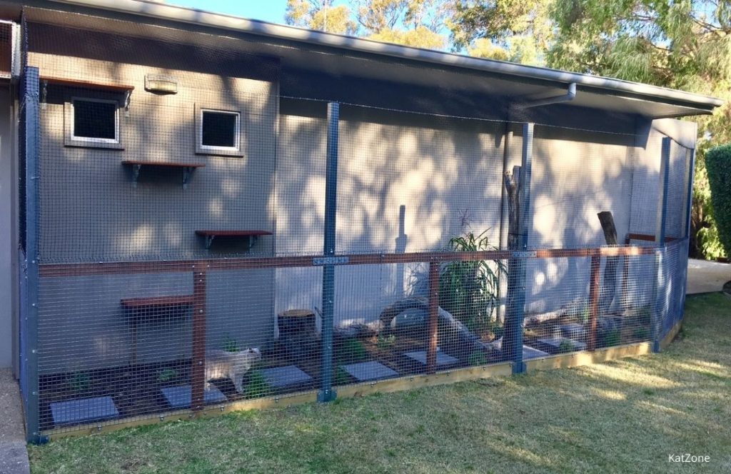
Covered catio

These can be either attached to an existing structure (house, garage, fence or shed) or freestanding. The total containment gives you full peace of mind knowing your cat will not get out and wildlife cannot get in.
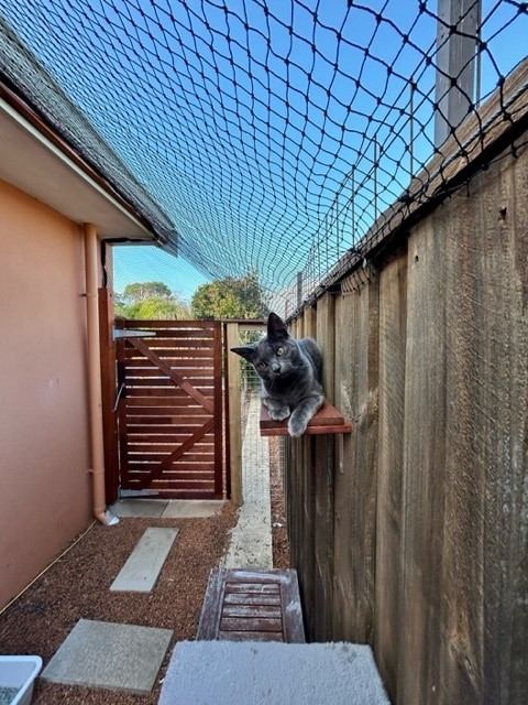
Open catio

These do not have overhead containment and rely totally on discouraging your cat from climbing over the property fences or walls, either using commercially bought ‘paddles’ that spin, or inward angled netting. Wildlife (flying and climbing) can still access the catio, so extra care should be taken with design and plant selection.

Indoor playground

Cats love high vantage points and being able to observe life outside. Easy access to window(s) and viewing perches is important, so they can engage with the sights, sounds, and smells of the great outdoors.

For all types of catios, there are lots of ways you can help satisfy the inner house panther by

  • increasing the area your cat can explore,
  • introducing level changes and perches or raised walkways with observation decks and resting platforms,
  • providing lots of choice – in bedding, scratchy surfaces (vertical, horizontal), and places to hide or explore (tunnels, boxes), and
  • including things your cat can sniff or nibble (cat grass is a must have item!).

Creating a catio

There are endless commercial and DIY options for catios to suit all budgets, tastes and locations. To get started creating your own catio, you will need to consider:

  • Which part of the garden/house works best (circulation, sun/shade)?
  • How will my cat access the catio (tunnel, window, door, wall cut)?
  • What space and budget is available?
  • How will you access the catio?
  • Will you build it or get someone to install it for you?
  • What construction style is the best suited to your situation?
  • What materials and finishes for building and features is cat safe?
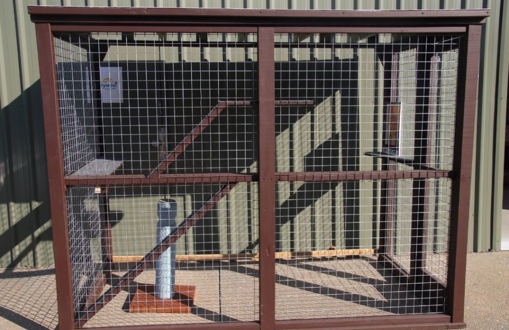
Catio construction

Catios range in size, shape and materials from timber and wire window boxes to metal frame and mesh walk-in structures, to expansive netted garden areas.

The key elements of a catio are:

  1. Access point(s) for cats
  2. Access/door(s) for humans (for maintenance + use)
  3. Frame (supports and/or wires)
  4. Mesh or netting sides
  5. Mesh/netting/polycarb roof
  6. Shelving/platforms/poles
  7. Planting areas/lawn/pots
  8. Litter trays/mulch areas

Resources

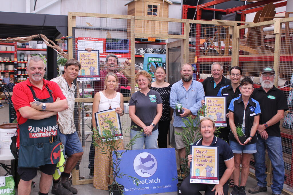
Catio Design Guide by Geocatch

GeoCatch Recommended suppliers and installers Catio Services

Catio Planting Guide

Responsible Pet Pawrents Program, South West NRM

catssafeathome.org

catiospaces.com

safeandhappycats.com.au – RSPCA

Happy at Home – Perth South West Metropolitan Alliance

Keeping cats content in catios by Dr Heather Crawford, Murdoch University

DIY Cat run installation ideas from catnet.com.au 

Receive the latest updates

Subscribe To Our Newsletter

My Pet, My Community

Grab your bin sticker! Enter your details below and collect from the GeoCatch office, 72 Duchess St Busselton.

Keep in touch with us

Join our Volunteer Register!

Buayanyup

The headwaters of the Buayanyup River occur in state forest where four tributaries flow through native vegetation before flowing through agricultural land. The lower section has been straightened into drainage channels, before flowing into Geographe Bay at Abbey.

The Buayanyup River catchment has a diversity of land uses, including beef and dairy farming, vineyards and horticulture. Native vegetation and timber plantations occur in the south eastern corner of the catchment, and the growing townsite of Vasse occurs in the lower catchment. Nutrients, particularly nitrogen, enter the river from dairy and beef grazing, dairy sheds and horticulture.

Native species, including the Western Minnow, Western Pygmy Perch , Nightfish, Blue-spot Goby, Gilgie, Smooth Marron, Freshwater Shrimp, Koonac and Long neck turtle, have all been found in the river.

Five Mile

Five Mile Brook is a small waterway in the north of the catchment. It flows seasonally to Geographe Bay near Minninup Beach. Five Mile Brook is surrounded by agriculture, particular beef farming, with some urban areas at the south of Dalyellup Estate.

Five Mile Brook has poor water quality. This is due to sandy soil, which does not retain nutrients well, and extensive grazing agriculture in the catchment.

Water sampling by local school groups has found evidence of macroinvertebrates, tadpoles and turtles.

Gynudup

The Gynudup Brook catchment consists of two main tributaries; Tren Creek and Gynudup Brook. The headwaters of Gynudup Brook are in State Forest, which then flow across agricultural land before connecting with the Capel River west of Bussell highway.

The hydrology of the catchment has been extensively modified, containing many artificial drains to alleviate water logging in winter months. Most of the catchment is cleared for agriculture, and the waterways suffer from poor water quality.

Despite being significantly altered, the waterways in the Gynudup catchment provide refuge for several native species including freshwater shrimp, Western Minnow, Blue Spot Goby, Nightfish, Gilgie and the Long-necked Turtle.

Capel

The Capel River is the largest and only perennial river in the Geographe Bay Catchment, receiving groundwater discharge from the Leederville aquifer year-round. Several foreshore reserves of conservation value are situated on the Capel River, including Ironstone Gully Falls.

Land use of the upper Capel River catchment is predominately native vegetation and beef farming. The lower catchment is dominated by beef and dairy farming with pockets of native vegetation and horticulture. The townsites of Capel and Peppermint Grove Beach also occur in the catchment.

The Capel River has relatively good water quality. Carters Freshwater, Smooth Marron, Gilgie, Freshwater Cobbler, Nightfish, Western Pygmy Perch, Western Minnow and Pouched Lamprey can be found in the catchment.

Ludlow

The Ludlow River is the only major waterway to discharge to the Wonnerup Estuary. Its upper catchment lies in the Whicher National Park, after which it flows across the coastal plain through grazing and dairy farmland, horticulture and turf farms.

These land uses contribute nutrients to the river, which suffers from poor water quality. There has been, however, a decreasing trend in nutrient concentrations in the river since 2011.

The Ludlow River retains native aquatic fauna including the Gilgie, Freshwater Shrimp, Nightfish, Western Minnow, Western Pygmy Perch and the Blue Spot Goby.

Abba

The Abba River begins in the Millbrook State Forest, flowing seasonally across the Swan Coastal Plain, through the Ludlow Tuart Forest and eventually into the Vasse Estuary. Landuse in the Abba sub-catchment is predominantly beef and dairy farming, with smaller amounts of sheep farming, vineyards and horticulture.

Ecological surveys of the river have found a diversity of native fish and freshwater crayfish including the Western Minnow, Nightfish, Blue-spot Goby, Western Pygmy Perch, Gilgie and Freshwater Shrimp.

The Abba River is categorised as an ‘intervention’ sub-catchment for water quality, where it meets phosphorus targets, but not nitrogen. Fertiliser for pasture is the largest source of nutrients to the river. We work with landholders and our partners to reduce these nutrients by fencing waterways, fertiliser management and dairy effluent upgrades.

Sabina

The Lower Sabina River flows into the Vasse Estuary. It is separated from its upper catchment, which is diverted into the Vasse Diversion Drain.

The Lower Sabina catchment is small, mostly cleared, with agricultural landuses dominated by dairy and beef farming. The river contributes a significant amount of nutrients to the Vasse-Wonnerup Wetlands.

The river supports Gilgie, Southwest Glass Shrimp, Nightfish, Western Minnow, Western Pygmy Perch and the Blue Spot Goby.

Lower Vasse

The Lower Vasse River flows through the centre of Busselton, extending from the Vasse Diversion Drain at its headwaters, to the Vasse Delta Wetlands at the downstream boundary. The river receives winter flow from the Vasse Diversion Drain through a 900 mm culvert.

The lower catchment is dominated by urban, residential development, while the upper catchment is primarily beef grazing.

The Vasse River suffers from poor water quality and in summer months experiences regular algal blooms. Despite these water quality problems, the Lower Vasse River retains significant ecological values, including a high diversity of fish and native crayfish.

Vasse Diversion

The Vasse Diversion Drain receives water from approximately 60% of the Sabina River catchment and 90% of the Vasse River catchment, diverting flow away from the Vasse-Wonnerup Wetlands and directly into Geographe Bay. These rivers were diverted in the 1920s to protect the Busselton townsite from flooding. The headwaters of these rivers originate in the Whicher Range, then flow across the coastal plain to the diversion drain and eventually to Geographe Bay in West Busselton.

The Vasse Diversion Drain catchment suffers from poor water quality, with phosphorus and nitrogen inputs high. Most nutrients come from the dominant land uses of beef and dairy farming, and smaller amounts from the Busselton wastewater treatment plant.

The upper Vasse and Sabina rivers retain important natural values, including several species of freshwater fish and crayfish. The lower section of the drain near Geographe Bay has important social and recreational value to the community.

Carbunup

The headwaters of the Carbunup River begin on the Whicher Scarp in the Treeton State forest. The river flows in a northerly direction through agricultural land before discharging into Geographe Bay near Siesta Park.

The upper reaches of the river are densely vegetated, however the lower reaches have been cleared and straightened into Lennox River Drain. A weir at the junction of the river and drain prevents saltwater from impacting arable farmland. Due to the dense riparian vegetation and high phosphorus retention index (PRI) of the soil, the Carbunup river has relatively good water quality.

A diverse range of aquatic fauna rely on permanent pools of water that provide refuge over warmer months. Carter’s Freshwater Mussel and Western Pygmy Perch have both been recorded in the river.

Annie

The Annie Brook catchment has three streams – Station Gully, Annie Brook and Mary Brook. These streams begin on the Whicher Scarp and Leeuwin-Naturaliste Ridge, before flowing to the coastal plain where they are artificially straightened into drains that converge at Station Gully before entering Geographe Bay.

The catchment features remnant native vegetation, including some poorly represented vegetation complexes. On the coastal plain, the catchment is mostly cleared for beef farming and smaller amounts of horticulture and viticulture. These land uses contribute nutrients to waterways, particularly nitrogen.

The endangered Dunsborough burrowing crayfish is known to occur in the waterways of the catchment, and surveys have also shown a variety of including the Gilgie, Marron, Nightfish, Western Minnow the Western Pygmy Perch.

Toby Inlet

Toby Inlet is located east of Dunsborough and runs parallel to the coast. It is surrounded by residential areas and is of social and recreational importance to the local community and visitors.

Land use in the wider catchment consists mostly of large rural properties and agriculture. A series of headwaters, originating on the Leeuwin-Naturaliste Ridge, flow across the coastal plain where they become poorly defined. The mouth of the Inlet closes naturally over summer but is opened by the City of Busselton to maintain flushing, as nitrogen levels are currently high.

The Inlet provides habitat for the Swan River Goby, Gilgie and the Dunsborough burrowing crayfish, as well as waterbirds and frogs.

Dunsborough

The Dunsborough streams include Meelup, Dolugup, Dandatup and Dugulup Brooks. Although relatively small and seasonal, the streams are significant to the local community.

They currently maintain good water quality due to their low nitrogen and phosphorus levels. However, the streams are at risk from nutrient runoff primarily from urban and rural-residential sources, including septics, due to their proximity to the Dunsborough townsite.

The streams provide a diversity of habitat and food sources for native fauna and are known to support the Gilgie (Dandatup and Dugulup Brooks), Marron (Meelup Brook) and the Blue Spot Goby (Meelup Brook).

Jingarmup

Jingarmup Brook is a small waterway that flows seasonally across the eastern slopes of the Leeuwin Naturaliste Ridge, through the Eagle Bay townsite to Geographe Bay.

The Jingarmup Brook catchment is categorised as an ‘intervention’ catchment, meeting phosphorus targets but not nitrogen. Native vegetation and beef farming are the dominant land uses in this catchment, which is the southern most region of the Geographe Bay Catchment. 

Water quality is impacted by septics, which contribute a significant amount of the phosphorus load to the waterway, and farming practices. Nitrogen levels are currently high in this waterway. The Meelup Regional Park Management Committee have made significant efforts to restore the riparian zone on lower section of the brook, which supports local biodiversity.